


Quantifying the multidimensional impacts of extreme weather events on water quality

Abstract
With the increasing impact of climate change, extreme weather events such as floods, droughts, wildfires, and heavy rainfall significantly affect inland water quality. However, accurately measuring their intensity, duration, and frequency, as well as quantifying their effects on water quality, remains a challenge. This study employs remote sensing (Sentinel-2, Landsat, MODIS) and GIS tools (ArcMap) to standardise the measurement of extreme weather events and assess their impact on key water quality parameters, including nutrient levels, algal blooms, and sediment load. NDWI (Normalised Difference Water Index) is used to analyze water extent, NDVI (Normalised Difference Vegetation Index) to assess vegetation conditions, and TSM (Total Suspended Matter) to measure sediment load. Additionally, machine learning and statistical models are applied to predict water quality changes. The findings provide a standardised framework for monitoring water resources and improving adaptive strategies in response to climate change.
Research Summary
Proposed completion date
2025
Research objective
- Standardise the measurement of three key dimensions of extreme weather events: intensity, duration and frequency.
- Quantifying the impacts of these dimensions on inland water quality using remote sensing technologies and GIS tools.
Research problems
Extreme weather events, including floods, droughts, wildfires, and extreme rainfall, significantly alter inland water quality. The unpredictable and multifaceted nature of these events complicates accurate measurement and impact assessment. Current methodologies often rely on localised, time-intensive field studies, failing to capture large-scale and continuous data. This research seeks to address:
- How can we effectively measure the three dimensions of extreme weather events using remote sensing?
- What is the quantifiable impact of these dimensions on water quality parameters such as nutrient levels, algal blooms, and sediments?
Benefits to the water sector
Understanding and quantifying the multidimensional impacts of extreme weather events on water quality will:
- Provide standardised frameworks for monitoring and management;
- Enhance disaster response strategies by integrating spatial and temporal analyses;
- Inform adaptive measures to protect water resources in the face of climate variability.
Findings to date
Preliminary conceptual frameworks have been developed:
- Mapping of extreme events overlaid with watershed boundaries to identify affected areas.
- Remote sensing data has been conceptualised to analyse the intensity (e.g., flood area, drought severity), frequency (event occurrence patterns), and duration (temporal persistence) of events.
- Conceptual diagrams (see Figures 1 and 2 on page 2) demonstrate the influence of extreme events on water quality metrics.
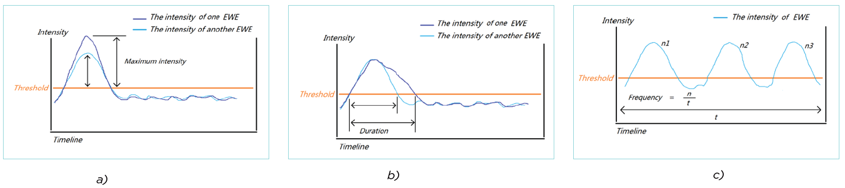
Figure 1. Conceptual diagrams show the a) intensity, b) duration, and c) frequency, three dimensions of extreme weather.
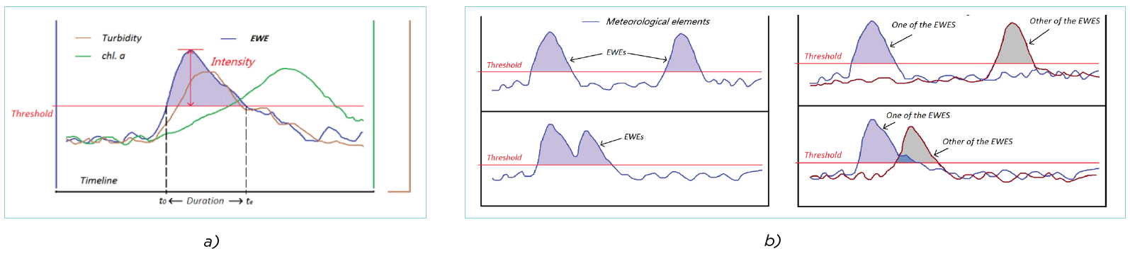
Figure 2. Conceptual diagrams of water quality changes with a) intensity and duration, and b) frequency of extreme weather events. Extreme weather occurs when meteorological element values exceed the threshold.
Author
Student: Jiatan Liang, Australian Rivers Institute, Griffith University
Email: tori.liang@griffithuni.edu.au
Phone number: 0493700116
Supervisors: David Hamilton, Andrés Felipe Suárez Castro, Brendan Mackey, Tim Malthus
Share