


NSW Supreme Court overturns initial Brisbane Flood class action decision
First published in Water e-Journal Vol 6 No 1 2021.
Judges reverse original court findings and determined that the decision be set aside, and ordered Seqwater’s cost of appeal to be paid by the plaintiff.
DOWNLOAD THE PAPER
Abstract
This paper tries to explain the history of deciding culpability for the 2011 Brisbane floods. In September 2021 the NSW Supreme Court of Appeal overturned the decision of the initial class action trial judge who found that three branches of government (QG, Sunwater & Seqwater) were liable to pay compensation (about $800M) for flood damages. Seqwater subsequently appealed this decision. The paper commences with a brief explanation of the legal concept of liability for individuals & public institutions, and then proceeds to document the decisions of the flood engineers managing the operation of Wivenhoe Dam as events quickly unfolded during the extreme rainfall events of early January 2011. The facts are presented without (authors’) interpretation, but are interweaved with quotes from the class action trial judge, and the subsequent comments by the appeal judges. We found one comment from the appeal judges particularly illuminating. viz … " (only) the owners of properties which suffered inundation as a result of the flows exceeding 8,300m3/s were, on Rodriguez’ case, entitled to recover their losses." The peak flood flow through the urban area was 10,700 m3/sec. The class action lawyers have now applied for leave to appeal to the High Court. A decision on whether the High Court will agree to hear the appeal is not expected until 2022.
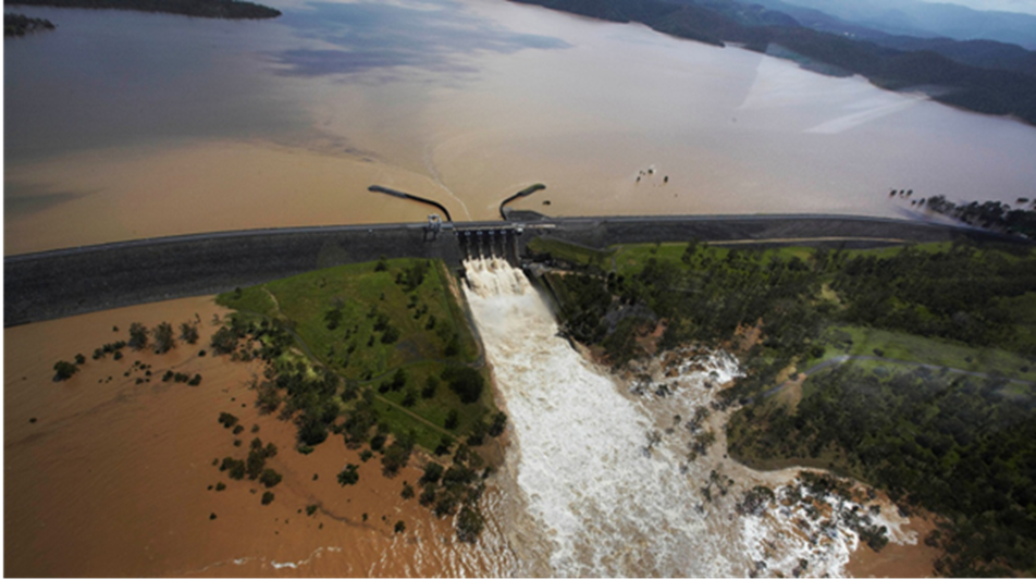 Figure 1. Wivenhoe Dam during flood discharge on 11th January 2011. Photo by Dean Saffron, Queensland State Library
Introduction
In early January 2011, South-East Queensland was subjected to a major storm event which caused significant flooding in the cities of Brisbane and Ipswich. That storm followed an earlier event in late December 2010 which resulted in saturated catchments and storage dams at their full water supply capacity, although with virtually empty flood storage capacity. The largest dam within the Brisbane River catchment, Wivenhoe has two conflicting functions: to maximise the supply of urban water to South-East Queensland, and to mitigate flooding. Specific storage volumes are allocated to these two functions. During the January event, water was released from Wivenhoe Dam at the same time as flows from downstream tributaries approached their peak rate, resulting in a higher flood peak than would have otherwise occurred had the releases been made earlier.
In 2014 a business which had suffered damage during the flood, Rodriguez and Sons Pty Ltd, commenced a class action on behalf of some 6,500 other members claiming damages due to the alleged negligence on the part of the dams' operators. The action was funded by a litigation firm. The hearing was held before the Common Law Division of the Supreme Court of New South Wales as the Queensland legal system did not have provision for class actions at that time. The judgement, delivered in November 2019, held that the state of Queensland, and the two statutory organisations responsible for operating the dam (Seqwater and SunWater) were negligent. Rodriguez & Sons Pty Ltd v Queensland Bulk Water Supply Authority (2019)1. An additional judgement allocated the liability as 50% to Seqwater, 30% to SunWater and 20% to the state of Queensland.
SunWater and the State settled their claims with Rodriguez, but Seqwater lodged an appeal with the Court of Appeal of the Supreme Court of NSW. This was heard during May 2021 before a panel of three justices, and in a judgement delivered in September 2021, reversed the decision of the initial hearing and determined that the earlier decision be set aside. Queensland Bulk Water Supply Authority t/as Seqwater v Rodriguez & Sons Pty Ltd (2021)2.
This paper aims to summarise the main arguments in the 324-page decision to reverse the ruling of the earlier court. It attempts to describe in simple terms the sequence of events leading up to the flood and the principal reasons given by the three appeal judges for their decisions.
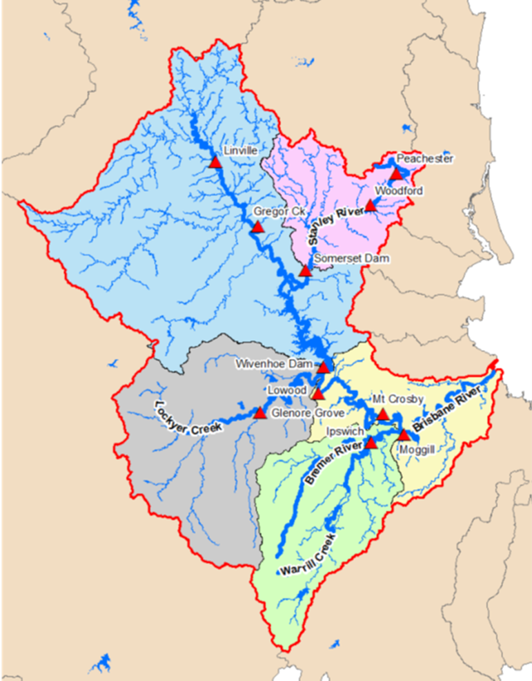
Figure 2. BRISBANE RIVER BASIN - Showing Major River Catchments and Stream Gauges. Source: Seqwater Manual of Operational Procedures for Flood Mitigation at Wivenhoe Dam and Somerset Dam Nov 20197
The Storage Dams
Wivenhoe and Somerset Dams are located in the catchment of the Brisbane River upstream of the city of Brisbane (Figure 2). Somerset, completed in 1956, is located upstream of Wivenhoe on the Stanley River, a tributary of the Brisbane River. Wivenhoe (The Dam) has a capacity at Full Supply Level (FSL) of about three times that of Somerset, and its catchment encompasses about 50% of the total Brisbane River catchment. Travel times for all of the sub catchments are of the order of 15 to 20 hours.
Both dams are owned and operated by The Queensland Bulk Water Supply Authority (trading as Seqwater). The spillway crest of Wivenhoe is set at 57.0m(RL) but water is normally held above this level by five radial gates. The Dam is also fitted with low level regulators to release water into the Brisbane River (The River). Water for domestic purposes is abstracted from The River at the Mt Crosby Treatment Plant, about 50km downstream of The Dam. The operational Full Supply Level (FSL) of The Dam is set at 67.0m (RL) and the top of the core of the embankment is located at 80m(RL). The dam is also provided with auxiliary spillways constructed in 2005. These are fitted with three “fuse plug” embankments designed to erode and release water down to the FSL of RL67.0m. The trigger levels of these fuse plug embankments are RL75.7m, RL76.23m and RL76.78m. Should any of these fuse plugs become eroded, the subsequent water release is uncontrolled.
Water supply capacity of the dam at FSL (RL67.0m) is 1,165 GL. The Flood Storage is provided by the volume between RL67.0m and RL75.7m providing an additional temporary storage of 1,180GL. Two major unregulated tributaries of the Brisbane River, Lockyer Creek and the Bremer River, enter below Wivenhoe Dam but upstream of the City of Brisbane.
The operations of both Wivenhoe and Somerset Dam are guided by a Flood Operations Manual6 (The Manual). A copy of the section of The Manual detailing flood operations, in force at the time of the 2011 Flood, is included as Appendix A to the 2021 appeal judgement. (This can be downloaded from https://www.caselaw.nsw.gov.au/decision/17bbdb214b08e61165013705 )
The manual sets out the following objectives, in decreasing order of priority
- Ensure the structural safety of the dams
- Provide optimum protection of urbanised areas from inundation
- Minimise disruption to rural life in the valleys of the Brisbane and Stanley Rivers
- Retain the storage at Full Supply Level at the conclusion of a Flood Event
- Minimise impacts to riparian flora and fauna during the drain down phase of a Flood Event.
The Manual provided four operational scenarios referred to as Strategies.
Strategy W1 - Triggered when the water level in Wivenhoe is predicted to exceed RL 67.25m. The primary consideration is minimising disruption to downstream rural life - the intent of this strategy is to ensure bridges downstream of the dam are not submerged prematurely (Objective 3). The upper limit of flow for Strategy W1 is approximately 1900m3/sec, above which, the bridge at Mt Crosby would be submerged. (See Fig 3).
Strategy W2 - Triggered when the water level is predicted to exceed RL 68.5m as well as flows downstream at Lowood and Mogill flood gauges are predicted to be < 3,500m3/sec, and <4,000m3/sec respectively. This is a transition strategy where the primary consideration changes from minimising impact to downstream rural life (Objective 3) to protecting urban areas from inundation (Objective 2). This strategy aims to limit the flow in the Brisbane River to the naturally occurring peaks at the downstream flood gauges at Lowood and Moggill, (See Fig 2) and maintaining the flow at Lowood below damaging flood levels (<3,500m3/sec).
Strategy W3 - Triggered when the water level is predicted to exceed RL68.5m and downstream flows at either Lowood or Moggill are predicted to exceed 3,500m3/sec and 4,000m3/sec respectively. The primary consideration is protecting urban areas from inundation (Objective 2) - this is to be achieved by limiting the peak flow at the Moggill gauge to below 4,000m3/sec.
Strategy W4 – Triggered when the water level is predicted to exceed 74m. The primary consideration is protecting the structural safety of The Dam (Objective 1).
Both river gauges mentioned in The Manual occur below the junctions with the major downstream tributaries. Hence, the operators must also make an assessment of flows from these unregulated tributaries. Figure 3 shows the location of the river crossings below the dam and submergence flows.
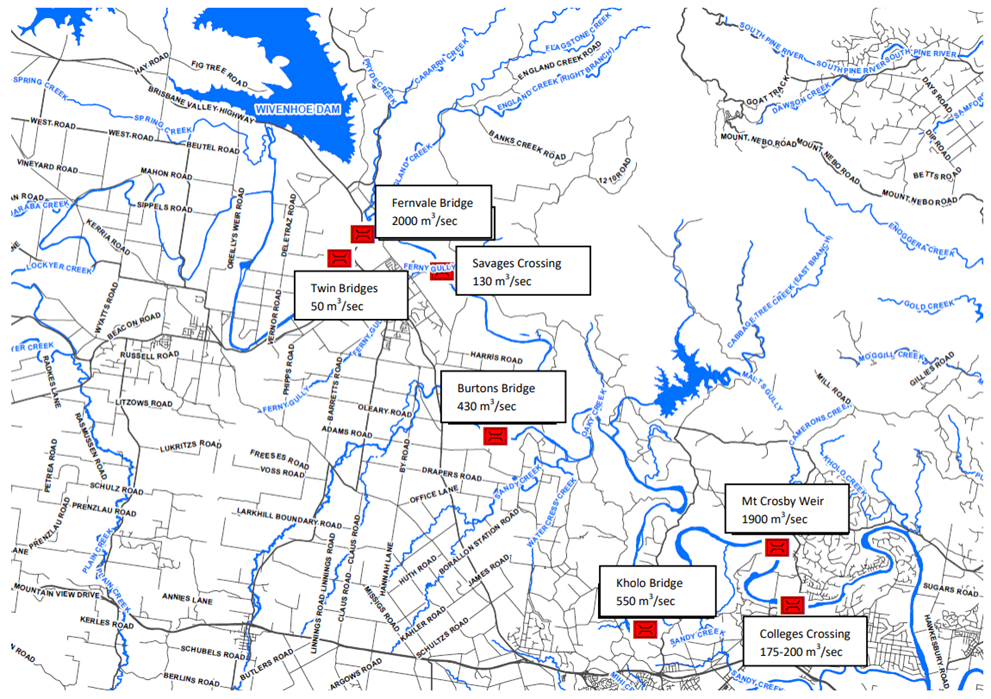
Figure 3 LOCATION OF LOW LEVEL RIVER CROSSINGS AND FLOWS (cumecs) CAUSING THEIR SUBMERGENCE. Source: Seqwater Manual of Operational Procedures for Flood Mitigation at Wivenhoe Dam and Somerset Dam. Dec 20096
The Manual also contained an explicit instruction relating to operation of the dam, "The spillway gates are not to be opened for flood control purposes prior to the reservoir level exceeding RL 67.25". To assist the operators during a flood situation, a real time modelling and forecast system was used. Input to the modelling was provided by radio telemetry data from a number of automatic rain and steam flow gauges throughout the catchment above and below the dam, and rainfall forecasts from the Bureau of Meteorology (BOM).
Standard of Care
A primary issue to be decided at the appeal was the standard of care that applied to Seqwater when operating the dam. The relevant legislation considered was the Civil Liability Act (2003) (QLD)3. Section 9 of this Act describes the duty of care as being based on the actions of a "Reasonable Person" placed in the position of the person accused of acting negligently. This is the normal standard that applies to individuals and organisations, requiring them to take reasonable care in their actions. However, another section, section 36, applies only to public or other authorities and is quoted in full.
"36 Proceedings against public or other authorities based on breach of statutory duty
- This section applies to a proceeding that is based on an alleged wrongful exercise of or failure to exercise a function of a public or other authority.
- For the purposes of the proceeding, an act or omission of the authority does not constitute a wrongful exercise or failure unless the act or omission was in the circumstances so unreasonable that no public or other authority having the functions of the authority in question could properly consider the act or omission to be a reasonable exercise of its functions."
An almost identical provision exists in Victoria, and probably other states, …. see S84 (2) Wrongs Act 1958(Vic)4.
The trial judge dismissed S36(2) as not applying in this case on two grounds:
The trial judge noted that S9(2) of the Water Restructuring Act5, which created the Queensland Bulk Water Supply Authority (aka Seqwater), conferred certain functions on the Authority to the extent that they are consistent with its operational and strategic plans. But Seqwater was unable to produce such plans specifically relevant to its flood management activities in force at the time. The trial judge held that "It follows that I am not satisfied that, in carrying out flood operations and flood mitigation, Seqwater was carrying out or performing any function conferred on it by S9(2) of the Restructuring Act.” However, the judge considered that Seqwater still had operational responsibility by virtue of its ownership of the dam, and consequently had liability for those actions, and hence was subject to the "Reasonable Person" test.
The appeal judges rejected this argument. The Water Restructuring Act specifically lists the functions of the new authorities to include, inter alia, carrying out water activities. The term "water activities" is a defined term having the same meaning as the (same) term defined in the Water Act. This specifically included flood prevention and flood control. Consequently, the appeal judges considered flood management and control to be a statutory function of Seqwater consistent with the requirements of S36(1) of the Civil Liability Act (2003)(Qld).
The second ground for the trial judge dismissing S36 was related to S36 referring to "wrongful exercise" of a function, rather than referring to the "liability" of an authority. The judge accepted the argument that, in this case, if the flood engineers’ actions were found to be negligent, then their employer would be responsible for the consequences. In other words, the argument was that it was not the Authority who was accused of wrongly exercising its function, but rather the individual flood engineers were being accused of negligence. As the engineers were not "a public or other authority " then S36(1) did not apply.
Again, the appeal judges dismissed this argument on the grounds that Seqwater was responsible for flood control as one of its functions. To carry out these functions Seqwater employed professional engineers as its agents. If the functions were found to be carried out negligently, then Seqwater would be liable. However, as Seqwater was a public authority exercising its functions, it met the conditions set out in S36(1). Consequently, the standard of care required would be that identified in S36 of the Civil Liability Act.
This decision meant that the actions of the flood engineers during the January 2011 flood event would be assessed by the appeal judges against the criteria set out in S36(2) ….viz Were their actions so unreasonable that no public authority having these functions could properly consider them to be a reasonable exercise of those functions?
Calculation of Predicted Water Levels
The Manual required that the strategy to follow (during a flood) was to be determined primarily on predicted water levels in The Dam. A question arose during the original hearing whether these predicted levels should be calculated from inflows only, assuming no release of water from the dam, or should any proposed releases be included when determining future predicted water levels. These releases can be significant, as the five radial gates are capable of rapidly releasing large volumes of water.
The trial judge held that predicted storage levels for the purpose of determining which operational strategy to select, should not take into account any volume of water to be released from the dam. His reasons included the following
“The requirement that the storage level in Wivenhoe Dam be determined without considering releases is consistent with the requirement that it is the ‘maximum’ storage level to be ascertained. By definition, the ‘maximum’ level is reached if there are no releases. This approach is also consistent with the other two predictions referred to in section 8.4 (of The Manual) which expressly require assessments of downstream flows without regard to Wivenhoe Dam releases.”
The Appeal Judges considered this question in some detail and concluded,
"The Manual proceeds on the basis that there will be an initial assessment (section 8.3) followed by an iterative reassessment of strategy continuously throughout the flood event (section 8.4). The repeated application of section 8.4 reflects the fact that conditions are apt to change throughout the flood event. Predicted rain may or may not fall, the weather forecast may change, and downstream flows may rise or fall depending on conditions in Lockyer Creek and Bremer River. For those reasons alone, it was necessary constantly to review the decisions which have been made to release water in light of conditions which may have changed subsequently.
However, the consequence of the procedure being iterative is that at all times, save at the commencement of the flood event, the procedure will unavoidably be derived in part from outflows that have occurred during the flood event to date. Why would one look into the relatively certain future of rain on the ground and the less certain future of predicted rainfalls, but ignore something squarely within the flood engineers’ control, namely, outflows? The natural meaning of the Manual when it asks, repeatedly throughout a flood event, about the maximum level at Wivenhoe, and whether the “Wivenhoe Storage Level [is] predicted to be” less than 68.5m, or between 68.5m and 74m, or to exceed 74m, is that it is asking a question of the predicted actual level of water in the dam. This will take into account such releases as have occurred, and those which are in fact being made at that time. There is no relevant certainty to be achieved by assuming that on-going releases cease.”
The 2011 Flood
2nd to 5th January 2011 - initial responses
In December 2010 and January 2011, two storm events occurred in the Brisbane River Catchment. During the first storm the water was released from The Dam, and by 2nd January the level had fallen to RL67.10m (about full water supply level) and the radial flood gates were closed. The duty Flood Operations Engineer declared the Flood Event over. At that time, the Bureau of Meteorology were forecasting less than 5mm of rain over the next 24 hours and a four-day forecast of between 2 and 10mm of rain. Declaring the Flood Event as over had the consequence of closing the Flood Operations Centre located in Brisbane’s CBD, and releasing involved staff and resources. These decisions were driven by two considerations
- The duty Operations Engineer considered that the dam had for all practical purposes been drawn down to its Full Supply Level. (67.0m), and
- Ceasing flow over the spillway allowed volunteers to rescue lung fish from the pond below the spillway as the volunteers were only available over the weekend. This was permitted by The Manual (Objective 5) which, although requiring the water level to be reduced to FSL (67.0m) within seven days of a flood peak, also permitted this requirement to be relaxed once the water level had been reduced to below 67.5m to achieve positive environmental effects, subject to favourable weather outlook. The Manual specifically referred to managing the final closure sequences so as to minimise stranding of fish downstream of the dam. It should be noted this objective (# 5) was of the lowest priority.
The trial judge noted that in evidence, the engineers estimated that 200mm of rain during the December event would have been sufficient to fill the reservoir to RL74m, and commented that while such a volume could be released so as not to cause urban flooding, it was a significant volume of water, and a deterioration in the forecast or significant rain beyond the forecast, could cause that to occur. Seqwater in response noted that in the event that additional rain were to fall, the time frame would be sufficient to allow significant discharge. The trial judge did not accept this argument pointing out that if significant rain fell in the catchment, it would probably also fall downstream of the dam's catchment and could exacerbate the effect of any releases. Consequently, in his opinion, the duty engineer should not have declared the Flood Event as being over, but rather should have continued to release water, because:
"The provisions of the Manual that address draindown (sic) and the conclusion of a flood event are directed to freeing up flood storage space before the onset of another flood event. Given the volatility of the weather in Brisbane at that time of year, what was known about the La Niña event, the state of the catchment, and the high runoff experienced in late December, such a draindown was necessary. According to the Manual, at the very least, a draindown to FSL should have been completed by 4.00pm on 3 January 2011 at the latest, that being seven days after the peak inflow during the late December flood event.”
He went to indicate that if it were necessary to rescue fish from the pond, the radial gates could have been closed for the necessary time, and then reopened to continue discharging water.
The Appeal Judges rejected this view. In their judgement they noted that The Manual explicitly permitted the level to remain above FSL (67.0m), but below 67.5m, for positive environmental effects provided there was a favourable weather outlook. They considered that the forecast given at the time expected less than 5mm of rain within the next 24 hours, and between 2 and 10mm over the next four days constituted such a favourable situation. They concluded that
"Those considerations made it not unreasonable for a flood engineer to form the view that the dam had, by the morning of 2 January 2011, returned to FSL, although in fact it was at 67.1m, rather than 67.0m."
Once the December flood event was formally declared as being over, the Manual expressly prevented the gates being opened for flood control purposes until the water level exceeded 67.25m.
The appeal judges went on to discuss the value of an early release of water in the event of a forecast of heavy rain on a wet catchment, but finally stated that
"We do not agree that a flood engineer acted beyond the range of reasonable discretion in not making further substantial releases of Brisbane’s drinking water when the outlook was as favourable as it was on 2 January 2011"
For the following three days (3, 4 and 5th January) inflow continued but the water level remained below the trigger level of 67.25m for gate opening, but above FSL of 67.0m (see Fig 5). The operations manual required that the duty flood engineer must declare a Flood Event if the water level was expected to exceed FSL (67.0m) as a result of prevailing or predicted weather conditions.
The duty engineers decided not to declare a Flood Event at that stage. On the 3rd of January there was little rain but the BOM forecast now predicted substantial rain of up to 150mm over the next three days. The eight day forecast indicated no significant rain beyond that period. The appeal judges considered that the decision not to declare a Flood Event on the 3rd, 4th or 5th was reasonable as the only action that a declaration at that stage would trigger was the opening and staffing of the Flood Operations Centre. This would serve no purpose as The Manual prohibited the release of flood water until the level reached 67.25m.
6th to 10th January - flood management
By 0600hrs on Thursday 6th January, the water level had risen 210mm to 67.31m (see Figures 4 and 5), and about 2 hours later the duty engineer mobilised staff for gate operations. The stated reason for doing this was the volume of overnight rainfall and a forecast issued at 0600hrs which predicted rainfall of up to 150mm over the next two days. The duty engineer advised his colleagues that his strategy at that stage was to open the radial gates at 1800 hrs, but limit the flow to keep Burton Bridge (see Figure 3) open. If rainfall increased and flow from Lockyer Creek (a downstream tributary shown in Figure 2) also increased, Wivenhoe gates could be closed/reduced as necessary to maintain traffic across this bridge. Heavy rain in the Lockyer catchment during the day (6th January) resulted in a later decision to defer the commencement of releases from Wivenhoe until the Lockyer peak passed. The duty engineer ran a number of simulations using the flood model during the afternoon, and concluded that Wivenhoe should peak at 68.51m on 11th January if no water were released.
Around 0800hrs on Friday 7th an updated forecast from the Bureau of Meteorology predicted the following rainfall totals,
- 15 to 50mm on Friday (7th)
- 15 to 50mm on Saturday (8th) with higher falls along the coast
- Widespread rain on Sunday (9th) with totals between 50 and 100mm
- Widespread rain on Monday (10th) with totals between 50 and 100mm
- Rain easing on Tuesday (11th) with totals between 25 and 50mm
The duty engineer advised that releases from Wivenhoe would begin that afternoon and be increased to 1200m3/sec, given the high likelihood of significant flows next week. They may be increased to 1500m3/sec to drain the stored floodwaters as soon as possible. This would result in the inundation of a number of bridges downstream.
Releases from the dam commenced at about 1500hrs on Friday 7th, and were gradually increased to about 1,240m3/sec by 1400hrs on Saturday 8th January (see Figure 4).
A model run at about 1800hrs on the 7th, predicted the maximum dam level at 68.51m during the afternoon of the 8th (assuming releases from the dam had continued for the previous 36 hours). At that stage, the level of the water in Wivenhoe was 68.12m (see fig 4 and Fig 5).
By 0800hrs on Saturday the 8th, the level of Wivenhoe was 68.52m. This occurred 6 hours earlier than the time predicted by the model run on the previous evening. By 1900hrs it had risen to 68.65m and remained at about that level until 2400hrs. The engineers increased the discharge so that by 0700 hrs on Sunday 9th, the outflow was about 1,334m3/sec. A model run at this time predicted a dam level of 68.66 m by 2000hrs. The run also indicated that the flows from downstream tributaries would have peaked by that time.
In the 24 hours up to 0900hrs on Sunday 9th January, average rainfall in the Wivenhoe catchment was 19mm, but the forecast for the next 24 hours was for 40 to 60mm, (in fact > 140mm were to fall in this period). The four day outlook predicted totals of between 50 and 300mm. The forecast also predicted substantial rainfall in the Lockyer Creek and Bremer River catchment, but in the 24 hours to 0900hrs on 9th January, very little rain had fallen in these catchments. The Senior Flood Operations Engineer called a meeting of flood engineers for 1500hrs. The meeting minutes noted that:
"The rainfall system is currently in the N-E part of the catchment and expected to travel south over the next 24-36 hours according to the BOM forecasts. This has the potential to significantly increase flows in Lockyer Ck & the Bremer River which potentially could close Fernvale Bridge and Mt Crosby Bridge and increase the risk of flooding in the Lower Brisbane. Releases from Wivenhoe Dam will be maintained at the current level of ~ 1,400 cumecs. If required, releases from Wivenhoe Dam will be reduced to contain the flow in the Mid-Brisbane to 1,600 cumecs, and 3,000 cumecs in the Lower Brisbane. At this stage it is anticipated that levels below 102.5m in Somerset, and 72.5m in Wivenhoe can be attained.”
At 1800hrs on the 9th January, the level in Wivenhoe was 68.7m. At 2100hrs the expected peak level of Wivenhoe was updated to 73.0m following heavy rainfalls of up to 140mm in the catchment over the previous 6 hours. This level was expected to occur sometime during 11th January. At 2100hrs on the 9th January Wivenhoe’s water level was at 69.1m and rising. The plan now was to increase Wivenhoe releases in the morning of January 10th but to minimise impacts on urban flooding by maintaining combined flows in the Lower Brisbane River to below 4,000m3/sec. The Manual noted that this was the maximum flow that could be passed downriver without creating urban damage in the city reaches of the Brisbane River.
Later modelling at 2100hrs on Sunday night 9th using the most recent forecast rain information now predicted a dam level of 75.11m, and significantly increased flows in the downstream tributaries. The peak rate at Moggill flood gauge (including releases from Wivenhoe) was now expected to be 5600m3/sec late on Monday 10th January, or early on the Tuesday 11th.
In the early hours of Monday morning (10thJanuary), the operators received a call from a senior manager at Brisbane City Council (BCC) advising that 3,500m3/sec was the maximum flow that could be passed without flood damage in the Brisbane urban area. Following discussions with Seqwater staff later in the morning, the manager was advised that the strategy would be to limit flows at the Moggill gauge within the range 3000 - 3500 m3/sec. The manager then indicated that even at a flow rate of 3,500m3/sec, over 300 properties would be fully submerged, and 7,000 affected in some way, with a damage estimate of about $7M. Following a discussion of the information provided by the Brisbane City Council officer, the duty engineers suspended further opening of the gates.
Meanwhile, water was rising rapidly in Wivenhoe. At 0100hrs on Monday 10th January, Wivenhoe water level was 69.97m, and at 0900hrs it was 71.56m, before reaching 72.07m by 1200hrs, coinciding with a water release of 2,053m3/sec. During the early morning of Monday 10th January, there were unprecedented inflows into Wivenhoe, increasing to a peak of 10,095m3/s at 0800hrs. Inflow then gradually subsided to 4,946 at 1900hrs and then to 3,594 at 0200hrs on Tuesday 11th. The appeal judges noted, that at the time of this peak (0800hrs on Monday 10th), the engineers were not to know inflows would then reach 8,060m3/s 24 hours later (0800hrs on Tuesday 11th January) followed by a second higher peak of 11,561m3/s at 1300hrs on Tuesday afternoon, before slowly falling to 8,196m3/s at 1700hrs. By early afternoon of Monday (10th), operations were moving from urban damage control (Objective 2) to dam safety priority (Objective 1) and further opening of the gates recommenced after a delay of about 5 hours. (Early on Monday afternoon, extreme rainfall on the steep escarpment south-west of Wivenhoe resulted in a flash flood wave down Lockyer Creek, a tributary of the Brisbane River but downstream of the dam, resulting in major property damage and loss of life.)
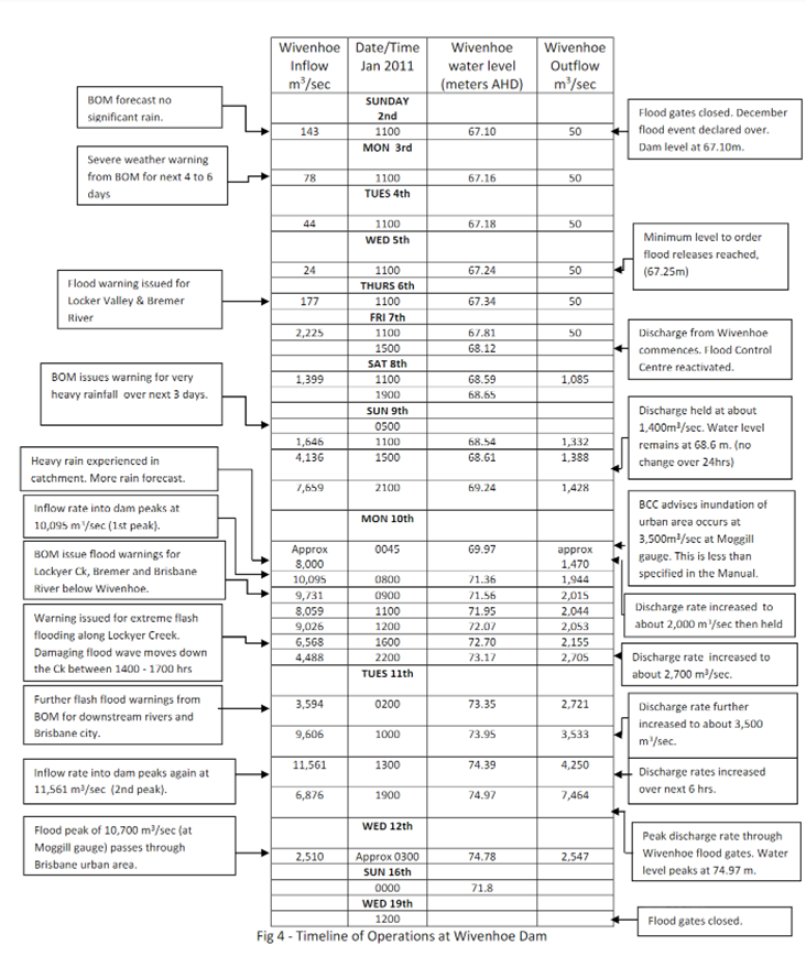
By 2200hrs on Monday, the discharge rate was 2,705m3/sec, increased to 3,500m3/sec by 1000hrs on Tuesday. Discharge was then rapidly increased from 1300hrs on Tuesday 11th over the next 6 hours until a peak discharge rate of 7,464m3/sec was being released at 1900hrs on Tuesday evening. Ultimately, the flow at the Moggill flood gauge reached about 10,700m3/sec during the early morning of Wednesday (12th January) causing major urban flooding in Brisbane and Ipswich. A timeline of operations at Wivenhoe is shown in Figure 4. A graph showing rate of inflow, rate of flood water releases as well as Wivenhoe water levels over the event period are shown in Figure 5. Figure 6 shows the extent of flooding of the urban areas of Ipswich and Brisbane. 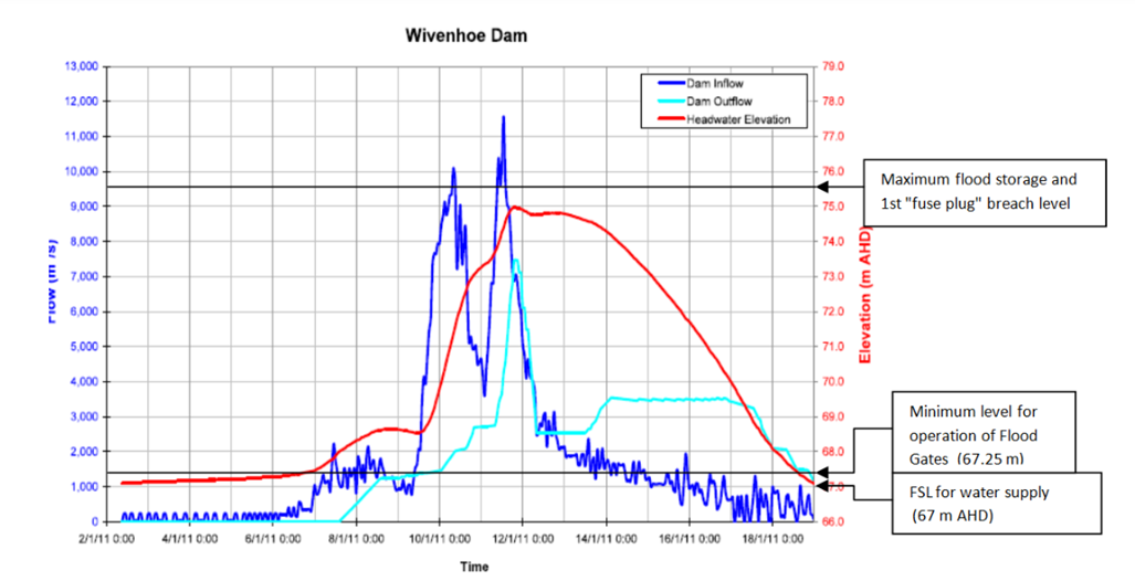 Figure 5 Wivenhoe Dam Water Levels and Flows, 2nd January to 19th January 2011. Source: Seqwater, January 2011 Flood Event Report on the Operation of Somerset Dan and Wivenhoe Dam, 2nd March..2011: http://www.floodcommission.qld.gov.au/__data/assets/pdf_file/0017/4292/QFCI_Exhibit_24_January_2011_Flood_Event_Report_on_the_Operation_of_Somerset_and_Wivenhoe.pdf
There was considerable discussion in the judgement about the operation of the (upstream) Somerset Dam flood gates during the period from 8th to 12th January, and the impact of these releases on Wivenhoe water levels. The judgement also discussed what constituted the "best available rainfall forecast”, but in the interests of simplicity, these discussions have not been included in this summary.
With regard to the urban flooding, the appeal judges noted:
"Effectively there were two contributing causes that led to urban inundation, that is to say flooding independent of any release from Wivenhoe and inflows into the dams on 11th January which required substantial releases from Wivenhoe. But on 7th January, and for most if not all of 9 th January, it was not clear that there would be any urban inundation at all. It was certainly not clear that the issue confronting the duty operator on 7th and 9th January was how best to minimise the urban inundation which (…. with the benefit of hindsight…) was to occur on 12th and 13th January."
At the initial trial, expert witnesses presented the results of simulation models based on their opinion of how the dams' flood gates could have been operated during early January. Essentially, the question posed was this; “Had the dams been operated differently, what would have been the outcome?” The modelling results demonstrated that even ignoring the releases from Wivenhoe, the flow from tributaries downstream of the dam were estimated to create flow rates of above >4,000m3/sec at the Moggill gauge from 2200hrs on 11th January, to about 2200hrs on 13th January, peaking at around 5,800m3/sec at 2400hrs on the 12th January. The actual event flow rates at the Moggill gauge exceeded 4,000 m3/sec from 0900 hrs on the 11th until around 0300hrs on 13th, peaking at about 10,700 m3/sec in the early hours of the 12th (Wednesday). Confidence in decision-making regarding further actions to undertake has increased as the onus is not on an individual to make and justify a decision, rather use of a validated tool. Having this systematic and reliable tool assists with making assessments and actions consistent over different incidents and different incident managers, thereby increasing regulator and customer confidence through an easily repeatable process.
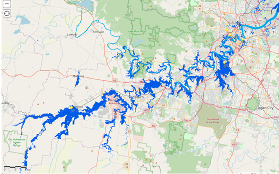
Figure 6 Extent of flooding in the Bremer and Brisbane rivers on 11th January 2011. Blue shaded area shows extent of inundation. (The flood wave down Lockyer Creek on 10 January had subsided by this time.)
Source: Jake Lovejoy from mapping software company ESRI, using Flood Layer from Allison Hoskin-Kain ( see https://storymaps.arcgis.com/stories/3bf04a8e0892421983cabcee416ee1e5)
The modelling also explored a number of different gate operating sequences that could have been followed. These scenarios resulted in predicted flow peaks at the Moggill gauge of between 7,000 and about 9,000 m3/sec from the sum of releases from Wivenhoe and inflows from downstream tributaries. The optimum sequence, proposed by the expert witnesses that could have been followed, based on information available to the engineers at the time, would have still resulted in a peak flow rate of about 8,300 m3/sec at the Moggill gauge. Consequently, the appeal judges concluded that if negligence were to be found, then only the owners of properties which suffered inundation as a result of the flow exceeding 8,300 m3/sec would be entitled to recover their losses.
Decisions by the Trial and Appeal Judges
In addition to the arguments listed above regarding accusations of negligence due to the failure to lower water levels between 2nd and 5th January, the trial judge also held that the operators were negligent for actions or inaction during the period 6th to 10th January. The major grounds for this finding was the judge's view that at some stage on 7th January, rainfall forecasts required moving to Strategy W3 (Protection of urban areas from inundation) and abandoning the plan to keep downstream bridges open. The judge particularly noted that given the forecasts and a saturated catchment, the prospect of 140mm of runoff was very likely. In those circumstances there was a serious and significant risk that if sufficient releases were not made at that time, later releases would have to be made from above 74m (the trigger level for moving to strategy W4, noting 74m is only 1.7m below the breaching level of the lowest fuse plug embankment).
The appeal judges noted that this finding depended on a number of possibilities coming to pass. They included the average of the forecast rain falling in the dam catchments over the four days; sufficient releases not being made from Wivenhoe in the three or four day period of that prediction; and heavy rain in the downstream Lockyer Creek and Bremer River catchments resulting in significant natural flow rates at Lowood and Moggill.
The appeal judges also noted that the forecasts on which the trial judge's finding was based did not become available until 1800hrs on the 7th January. Earlier forecasts received at 0600hrs indicated about 100mm of rain was expected over the next 4 days, and the duty engineer assessment from the Bureau's contour maps was that the highest falls were likely to be coastal and downstream of Wivenhoe.
The appeal judges found the conditions late on 7th January did support moving to Strategy W2 or W3, but it did not support the contention that a reasonably competent flood engineer "must" come to this conclusion.
The trial judge considered the actions of the duty engineers over the next two days, and basically concluded that the forecasts were such that they (the engineers) were negligent in failing to move to strategy W4. This decision was based on the consequences of "proper” modelling (i.e., assuming no release of stored water from Wivenhoe) using forecast rainfall depths being performed.
“It is overwhelmingly likely that either the predicted level of Wivenhoe dam would have exceeded 74m or the strategy of maintaining Fernvale Bridge and Mt Crosby Weir Bridge open would have had to have been abandoned.”
The appeal judges view was that,
"The analysis supporting that finding depended on a prediction which did not take into account the making of releases during the period of the forecasts. The evidence did not establish that a reasonably competent flood engineer, taking into account releases at rates and for periods assessed as necessary, must have predicted the dam level would exceed 74m."
The trial judge was also critical of the decision to suspend further gate opening for about five hours following receipt of the request from a manager at the City of Brisbane, and considered that decision as being unreasonable. The appeal judges however held that there was no evidence to suggest that acting on this request was so unreasonable that no authority in Seqwater’s position could properly consider doing so. The 4,000m3/s rate in the Manual is scarcely precise. The flood engineers were being told that making releases which would result in a flow rate of 4,000m3/s at Moggill would cause millions of dollars of damage. Conversely, the reduction of outflows from Wivenhoe by the requested 500m3/s was, in the scheme of things, a relatively minor proportion of the releases being made.
As a result of their considerations the appeal judges dismissed the orders made in the earlier proceedings against Seqwater and ordered that Seqwater's cost of the appeal to be paid by Rodriguez.
The legal activity will continue as lawyers for the class action have now applied for leave to appeal to the High Court. A decision of whether the High Court will agree to hear the appeal is not expected until 2022.
References
Rodriguez & Sons Pty Ltd v Queensland Bulk Water Supply Authority trading as Seqwater (No 22) [2019] NSWSC 1657.
Queensland Bulk Water Supply Authority t/as SeqWater v Rodriguez & Sons Pty Ltd [2021] NSWCA 206
Civil Liability Act (Qld), https://www.legislation.qld.gov.au/view/html/inforce/current/act-2003-016
Wrongs Act 1958 (Vic) Sec 84 (2), https://www.legislation.vic.gov.au/in-force/acts/wrongs-act-1958/127
Water Restructuring Act (Qld), https://www.legislation.qld.gov.au/view/pdf/inforce/2019-05-24/act-2007-058
Manual of Operational Procedures for Flood Mitigation…Wivenhoe Dam and Somerset Dam, December 2009 …Seqwater.
Manual of Operational Procedure for Flood Mitigation … Wivenhoe Dam and Somerset Dam, 2019 … Seqwater
About the authors
Bob Ford | Bob Ford is a retired civil engineer formally the Chief Engineer at Central Highlands Water providing water and wastewater services to the Ballarat region north- west of Melbourne, Victoria. He graduated from Sydney University with a degree in science and civil engineering and prior to joining the Ballarat authority worked for 10 years with the consulting firm GHD. Bob is also a member of the AWA WATER e-journal editorial committee. Bob has been a member of AWA since graduating and has held positions as President of the Victorian Branch and a Board Member of AWA's Federal Council.
Ted Gardner | Ted Gardner (PSM) is a retired scientist who spent most of his career in the Queensland government sector with a few of his final years in CSIRO. He has had wide experience in experimental soil research & hydrology, complemented by extensive research experience in water recycling and alternative urban water supplies. During his retirement, Ted has co-edited two books on urban water issues , mentored a number of post graduate students, and undertaken consultancies in waste water irrigation. He is currently an Adjunct Professor at Victoria University, as well as a member of the AWA WATER e-journal editorial committee.
Share