


An eco-geomorphological modelling framework for vulnerability assessment of coastal wetlands
First published in Water e-Journal Vol 7 No 1 2022.
DOWNLOAD THE PAPER
Summary
Our world is going through a quick transformation, and a significant effort has been made to develop models to predict the impacts of climate change and sea-level rise in the environment. However, many gaps are still open as a broad implementation of new powerful models is constrained by the lack of computational, human and financial resources. That is the case of vulnerability assessment of coastal wetlands. The most complex models demand lots of measured parameters and the computational costs to apply to a large system are pretty prohibitive. On the other hand, some works assessed vegetation loss over large areas, up to the global scale, using simple relationships between tidal range, the position of the vegetation in the tidal frame and average sediment concentration. Recent findings show that their predictions are inaccurate due to missing the feedbacks among vegetation, hydrodynamic of overland flow and sediment transport. Additionally, none of these simple models reproduces the effects of artificial structures as embankments and drainage ditches that are commonly found near habited coasts. In my research, we developed a modelling framework that successfully strikes a balance between data requirements, computational cost and complexity of the modelled processes. The figure below shows the prediction of coastal wetland area at multiple sites worldwide. While simplified models only identify mass vegetation mortality by the end of the current century, our model presents these episodes earlier, by 2050. These results are corroborated by paleological data that showed significant wetland losses in the past when the rate of SLR was similar to that predicted one for 2050. However, using the same framework, we found out that artificial structures can be used to manage vegetation retreat from their current place and transgression to new upland areas . This new framework can be implemented in any coastal area as it takes advantage of freely available modern global data sets (terrain and sediment concentration) plus relatively easy-to-estimate data about vegetation and accretion rates.
This new tool opens the possibility for city councils and states to plan their coastal infrastructure adequately, considering both the well-being of their citizens and the preservation of their rich coastal ecosystems.
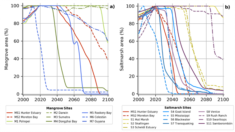
Figure 1 – Predicted changes in wetland vegetation area over the current century using RCP 8.5 (0.8 m by 2100) for multiple sites worldwide
Share